


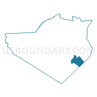
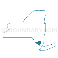
Voting District 230002, Orange County, New York
About
Outline

Summary
| Unique Area Identifier | 633626 |
| Name | Voting District 230002 |
| County | Orange County |
| State | New York |
| Area (square miles) | 18.79 |
| Land Area (square miles) | 18.01 |
| Water Area (square miles) | 0.78 |
| % of Land Area | 95.83 |
| % of Water Area | 4.17 |
| Latitude of the Internal Point | 41.29882930 |
| Longtitude of the Internal Point | -74.07929820 |
Maps

Graphs
Select a template below for downloading or customizing gragh for Voting District 230002, Orange County, New York


Neighbors
Neighoring Voting District (by Name) Neighboring Voting District on the Map
- Voting District 050002, Rockland County, NY
- Voting District 090002 090003, Orange County, NY
- Voting District 090004 090006, Orange County, NY
- Voting District 120002, Orange County, NY
- Voting District 120013, Orange County, NY
- Voting District 190002, Orange County, NY
- Voting District 230001 230008, Orange County, NY
- Voting District 230003, Orange County, NY
- Voting District 230004, Orange County, NY
- Voting District 230009, Orange County, NY
Top 10 Neighboring County Subdivision (by Population) Neighboring County Subdivision on the Map
- Monroe town, Orange County, NY (39,912)
- Stony Point town, Rockland County, NY (15,059)
- Highlands town, Orange County, NY (12,492)
- Woodbury town, Orange County, NY (11,353)
- Tuxedo town, Orange County, NY (3,624)
Top 10 Neighboring Place (by Population) Neighboring Place on the Map
Top 10 Neighboring Unified School District (by Population) Neighboring Unified School District on the Map
- Haverstraw-Stony Point Central School District, NY (47,775)
- Monroe-Woodbury Central School District, NY (36,585)
- Highland Falls Central School District, NY (12,482)
Top 10 Neighboring State Legislative District Lower Chamber (by Population) Neighboring State Legislative District Lower Chamber on the Map
Top 10 Neighboring State Legislative District Upper Chamber (by Population) Neighboring State Legislative District Upper Chamber on the Map
Top 10 Neighboring 111th Congressional District (by Population) Neighboring 111th Congressional District on the Map
Top 10 Neighboring Census Tract (by Population) Neighboring Census Tract on the Map
- Census Tract 136, Orange County, NY (6,763)
- Census Tract 142.02, Orange County, NY (6,491)
- Census Tract 135, Orange County, NY (6,267)
- Census Tract 101.01, Rockland County, NY (5,813)
- Census Tract 141.02, Orange County, NY (5,257)
- Census Tract 139, Orange County, NY (4,419)
- Census Tract 149, Orange County, NY (3,624)
- Census Tract 138, Orange County, NY (2,983)
Top 10 Neighboring 5-Digit ZIP Code Tabulation Area (by Population) Neighboring 5-Digit ZIP Code Tabulation Area on the Map
- 10950, NY (47,226)
- 10980, NY (13,383)
- 10930, NY (8,958)
- 10926, NY (3,203)
- 10986, NY (1,974)
- 10917, NY (1,968)
- 10975, NY (281)
- 10910, NY (21)